CSMP IAS : India's Premier Coaching Institute for IAS / PCS
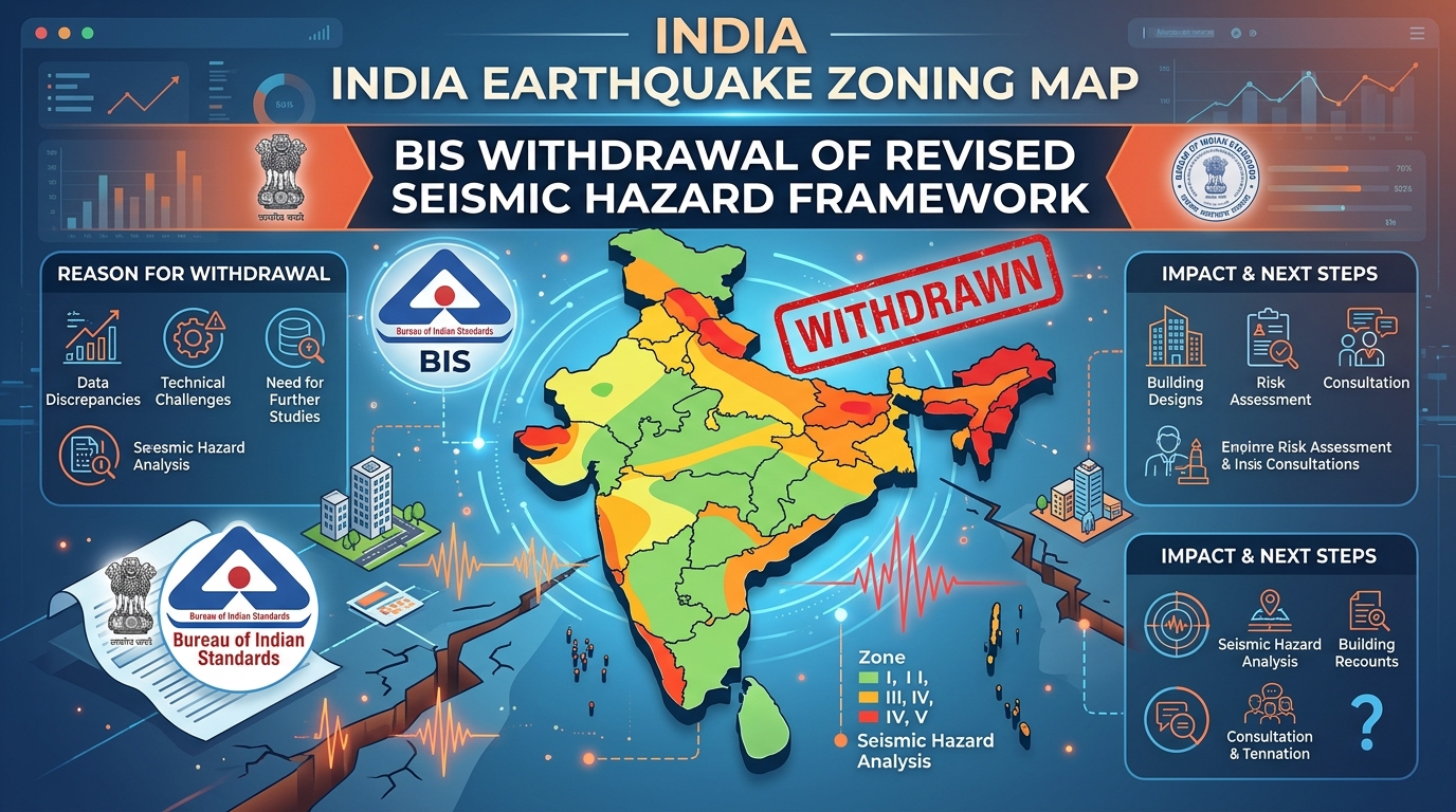
Earthquake Zoning Map India: BIS Withdrawal of Revised Seismic Hazard Framework
Table of Contents
Earthquake Zoning Map India has come under focus after the Bureau of Indian Standards (BIS) withdrew its proposed revision introducing a probabilistic seismic hazard assessment framework. The rollback highlights concerns over rising construction costs, infrastructure planning challenges, and balancing disaster safety with economic development.
Why in the News?
- The Bureau of Indian Standards (BIS) recently withdrew its proposed revision of India’s earthquake zoning map.
- The revision was notified in November 2025, but it was rolled back on March 3, 2026 after criticism from engineers, policymakers, and industry stakeholders.
- The proposed changes had major implications for urban planning, infrastructure development, disaster preparedness, and construction costs.
What are the Key Highlights?
- Existing earthquake zoning system
- India currently follows a fixed seismic zoning model.
- This system divides the country into zones based on earthquake risk.
- The zoning is used to guide building standards and infrastructure design.
- Proposal to shift to a modern framework
- BIS attempted to move toward Probabilistic Seismic Hazard Assessment (PSHA).
- PSHA is a probability-based scientific method used globally.
- It estimates earthquake risk by simulating possible ground motion and earthquake intensity.
- Introduction of a new high-risk category
- The proposed framework introduced a new high-risk category called Zone VI.
- This zone covered:
- Most of Kashmir
- Parts of the Himalayan region
- Kutch
- Parts of North-East India
- Concerns raised by experts and policymakers
- Some engineers argued that the methodology used in the revision was not fully aligned with site-based evaluations.
- Urban planners feared that stricter zoning could slow down development in economically weak regions.
- High cost implications
- Increasing the seismic zone classification can increase construction costs.
- Estimates show:
- One-zone increase may raise building costs by about 20%.
- Two-zone increase may raise costs by nearly one-third.
- Major infrastructure projects such as:
- Metro rail
- Dams
- Power stations
- could face even higher costs.
- Government departments raising concerns
- Objections came from several government institutions, including:
- Ministry of Housing and Urban Affairs
- Ministry of Home Affairs
- Central Water Commission
- National Dam Safety Authority
- Objections came from several government institutions, including:
- Impact on housing sector
- Around 80% of houses in India belong to the informal sector.
- Higher construction costs may push more people into unsafe informal housing.
- Climate dimension
- The construction sector is a major source of carbon emissions in India.
- Changes in building standards may increase material use and emissions.
What is the Significance?
Strengthening Disaster Preparedness
- Accurate earthquake zoning helps design safer buildings and infrastructure.
- It reduces loss of life and property during earthquakes.
Improving Urban Planning
- Proper zoning helps planners decide where and how cities should expand.
- It ensures safer location of buildings, transport systems, and public utilities.
Protecting Critical Infrastructure
- Infrastructure such as:
- Dams
- Highways
- Power plants
- Metro systems
- requires strong earthquake-resistant design standards.
Supporting Climate-Resilient Development
- Modern infrastructure planning must consider both disaster risk and climate change.
- Safe and durable structures reduce reconstruction and environmental damage.
Aligning with Global Scientific Practices
- The shift toward Probabilistic Seismic Hazard Assessment aligns India with global standards.
- It improves scientific accuracy in earthquake risk estimation.
Challenges
High Construction Costs
- Stricter seismic standards can significantly increase construction expenses.
- This can affect:
- Housing projects
- Public infrastructure
- Private sector investment.
Impact on Infrastructure Development
- Higher costs may slow down development projects.
- Economically weaker regions may face delays in infrastructure growth.
Expansion of Informal Housing
- Increased building costs may push people toward cheaper and unsafe housing.
- Informal housing is already very common in India.
Methodological Concerns
- Some engineers believe that the scientific methods used in the new zoning framework need further validation.
- Lack of detailed site-based assessments has been criticized.
Coordination Issues Among Institutions
- Several ministries and regulatory bodies have different views on the revision.
- Lack of coordination can delay policy implementation.
Environmental Concerns
- Stronger buildings may require more steel, cement, and construction materials.
- This can increase carbon emissions from the construction sector.
Way Forward
Conduct Wider Scientific Consultation
- The government should involve:
- Seismologists
- Structural engineers
- Urban planners
- This will improve the accuracy and acceptance of zoning frameworks.
Use Detailed Local Risk Assessments
- Earthquake risk should be studied through site-specific assessments.
- Local geological conditions must be considered before assigning zones.
Balance Safety and Development
- Policies should ensure both safety and economic feasibility.
- Development should not be completely restricted in high-risk areas.
Promote Affordable Earthquake-Resistant Construction
- Governments should encourage low-cost earthquake-resistant building technologies.
- Financial incentives can support safer construction.
Strengthen Institutional Coordination
- Ministries and regulatory agencies must work together to create a unified policy framework.
- This will improve implementation and monitoring.
Integrate Climate and Disaster Policies
- Urban planning must combine earthquake safety with climate mitigation goals.
- Sustainable construction materials and techniques should be promoted.
Conclusion
India’s rapid infrastructure growth requires careful planning to protect people and assets from natural hazards. Scientific knowledge, economic realities, and environmental concerns must be balanced while designing safety standards. A thoughtful and collaborative approach can help create stronger cities and safer communities for the future.
Relevant Articles:
Women in Agriculture: Invisible Labour and Rural Gender Gap in Farming Sector
Global AI Rivalry: Security Risks and Strategic Threats in Artificial Intelligence
Natural Gas Supply Prioritisation in India: Ensuring Energy Security Amid Global Crisis
Read Also:
Designer Proteins in Bacteria: Breakthrough in AI-Driven Protein Engineering
Empowering Women in AI Learning in India: Closing the Digital Gender Gap
Musi Riverfront Development in Hyderabad: Urban Renewal Amid Controversy