India-Nepal Relations: Historical Background, Border Disputes & Current Scenario | UPSC2026
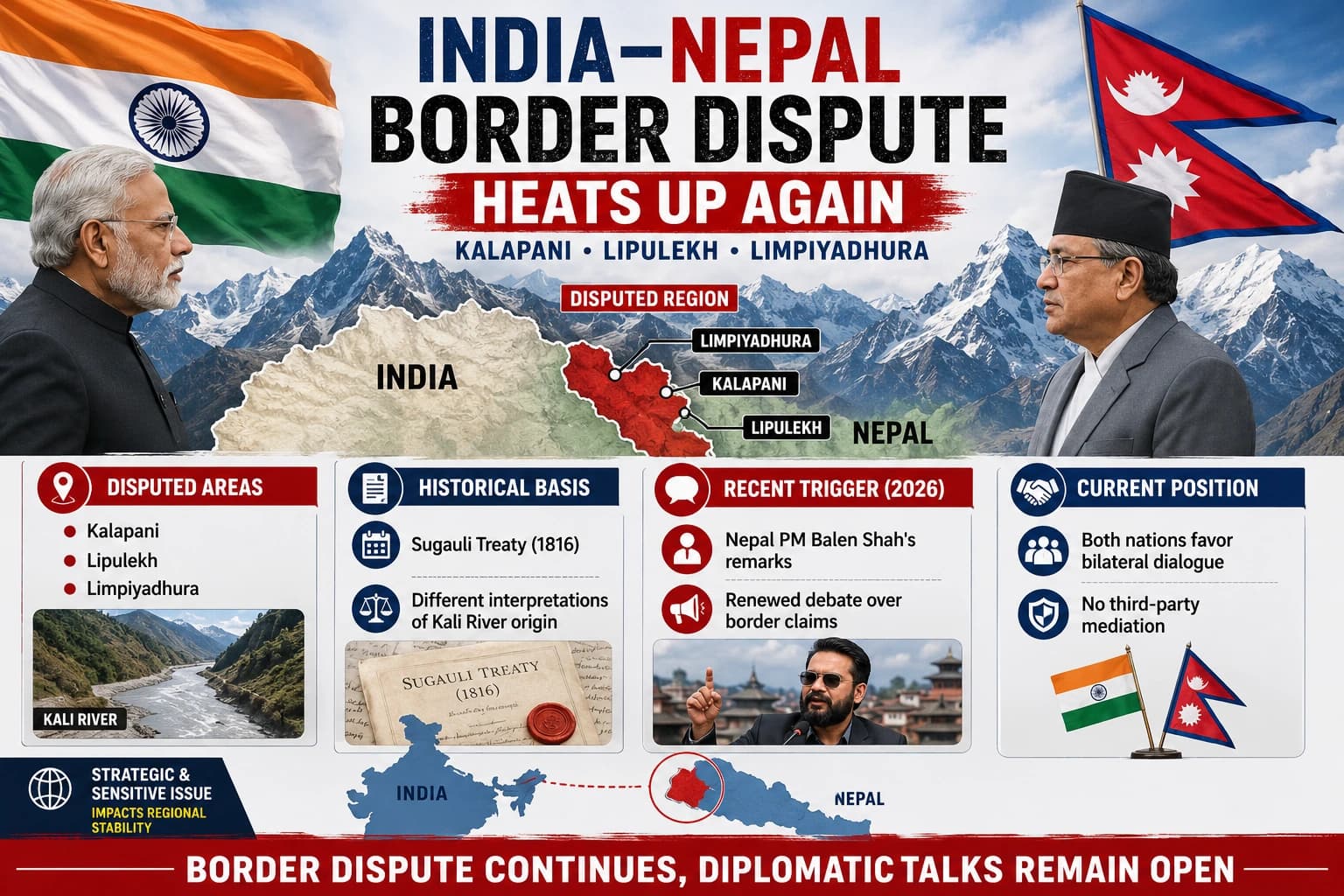
- UPSC 2026 | International Relations
- भारत-नेपाल संबंध: सीमा विवाद, रणनीतिक तनाव और आगे की राह
India-Nepal Relations: Historical Background, Lipulekh, Susta Dispute & Current Scenario — Complete Analysis
Updated: June 2026GS Paper II1750 km BorderTreaty of Sugauli, 1816
✦ GS-II: India & Neighbours✦ GS-III: Security✦ CLAT Legal Reasoning✦ Essay: Himalayan Diplomacy✦ Prelims High-Value Topic
- ⚡ Prelims Quick-Fact Capsule
- Border Length
~1,751 km open border (world’s longest open border between two countries)
- Treaty of Sugauli
- 1816 — defined Nepal’s western boundary as the Kali River
- 1950 Treaty
- Treaty of Peace and Friendship — Nepal calls it “unequal”
- Kalapani Altitude
- >5,000 m — strategic tri-junction (India-Nepal-China)
- Lipulekh Road
- 80-km road inaugurated by India in May 2020 (Dharchura → Lipulekh)
- Nepal’s New Map
2020 — includes Kalapani, Lipulekh, Limpiyadhura; added to Constitution
- Susta
- West Champaran, Bihar — river boundary dispute (Gandak/Narayani river)
- Bilateral Trade
- ~$8.5–8.7 billion (FY 2024-25); India = Nepal’s largest partner
- BRI
- Nepal joined China’s Belt & Road Initiative in 2017
- Boundary WG
- 7 th meeting resumed New Delhi, 2025 (after 6-year gap)
- Gurkha Issue
- Nepal suspended recruitment under India’s Agnipath scheme (2022)
- Pancheshwar Project
- Major hydropower project — implementation delayed due to trust deficit
- Exam Utility
- GS Paper Mapping
GS-II: India’s Neighbourhood PolicyGS-II: Bilateral RelationsGS-II: International TreatiesGS-III: Border SecurityGS-III: Strategic InterestsGS-IV: Ethics in DiplomacyEssay: Neighbourhood First Policy
🎯 Why This Topic Matters in 2026
The Lipulekh border dispute resurfaced sharply in 2025 when India and China agreed to resume the Kailash Mansarovar Yatra through the pass — Nepal strongly protested. Nepal’s Gen Z protests of 2025, China’s growing BRI footprint, and the Boundary Working Group’s 2025 resumption make this a high-probability Mains & Prelims topic.
- Historical Background
- नींव की कहानी: Treaty of Sugauli से 2020 तक
India and Nepal share one of the world’s most complex bilateral relationships — defined by civilisational kinship, an open border, deep economic interdependence, and an increasingly contested territorial legacy rooted in colonial-era treaties. Understanding the dispute requires tracing its roots to the 19th century
- 1814–16
- Anglo-Nepalese War & Treaty of Sugauli (1816)
Britain defeated Nepal in the Anglo-Nepalese War. The Treaty of Sugauli established the Kali River as Nepal’s western boundary with British India. This treaty is the root cause of today’s dispute — because the exact source of the Kali River remains contested.
- 1950
- Treaty of Peace and Friendship
Signed between India and Nepal, granting citizens of both countries equal rights to reside and own property. Nepal increasingly views this as an “unequal treaty” that compromises its sovereign autonomy.
- 1962
- India-China War & Kalapani Military Presence
Following the 1962 India-China war, King Mahendra reportedly allowed India temporary use of Kalapani for strategic purposes. India has since maintained ITBP presence there. Nepal now argues this was a temporary arrangement, not a territorial transfer.
- 1981
- Joint Technical Boundary Committee
Formed to identify and restore boundary pillars. It resolved ~98% of the 1,750-km border by 2008 but left Kalapani and Susta deliberately unresolved for higher-level diplomacy.
- 1998
- Nepal Formally Raises Kalapani
Nepal officially raised the Kalapani issue before India for the first time at a diplomatic level, bringing it into mainstream bilateral agenda. The issue was debated in India’s Lok Sabha in July 1998.
- 2014
- Modi’s Nepal Visit & Boundary Working Group
PM Modi visited Nepal; both sides agreed foreign secretaries would lead negotiations on border disputes. A Boundary Working Group was formed. In practice, no Foreign Secretary-level talks have taken place since.
- 2015
- Trade Blockade & China Card
India was accused of an informal economic blockade during Madhesi protests against Nepal’s new Constitution. Nepal reacted by deepening ties with China. In 2017, Nepal joined China’s Belt and Road Initiative (BRI).
- 2019
- India’s New Political Map
After reorganising J&K and Ladakh, India released a new political map that included Kalapani, Lipulekh, and Limpiyadhura within Indian territory. Nepal was shocked — protests erupted across Kathmandu.
- May 2020
- India Opens Lipulekh Road (80 km)
India inaugurated a new 80-km strategic road from Dharchula (Uttarakhand) to the Lipulekh Pass. Nepal called it a violation of its territory and demanded the road be stopped. India refused.
- June 2020
- Nepal Amends Its Constitution
Nepal’s Parliament endorsed a new political map incorporating Kalapani, Lipulekh, and Limpiyadhura. In a historic move, the constitution was amended and the new map was added to Nepal’s national emblem. India rejected the map as “unjustified.”
- 2025
- Boundary Working Group Resumes; Kailash Yatra Controversy
After a six-year pandemic-era gap, the 7th meeting of the Boundary Working Group resumed in New Delhi (2025). Separately, India and China agreed to resume the Kailash Mansarovar Yatra via Lipulekh — Nepal again protested, saying neither country should use the pass without its consent.
- 2026
- Nepal’s Foreign Ministry Protests Continue
As of May 2026, Nepal’s Foreign Ministry continues to lodge protests over Lipulekh. Nepal’s Gen Z protests of 2025 added internal political pressure. India and China are seen to be “ignoring” Nepal’s concerns over the pass.
India–Nepal border http://India–Nepal border Wikipedia https://en.wikipedia.org › wiki › India–Nepal_border
- Data Snapshot
- India-Nepal: Key Numbers
- 1,751
- KM
- Open Border Length
- 97%
- AGREED
- Border Demarcated
- $8.7B
- FY 2024-25
- Bilateral Trade
- 32,000
- TROOPS
- Gorkhas in Indian Army
- 5,000+
- METRES
- Kalapani Altitude
- 2017
- YEAR
- Nepal Joined China’s BRI
- Key Dispute #1
- लिपुलेख विवाद — Kalapani-Limpiyadhura-Lipulekh Triangle
- 🏔 Strategic Geography: The Tri-Junction
The Kalapani-Limpiyadhura-Lipulekh triangle sits at the tri-junction of India, Nepal, and China in the western Himalayas. Lipulekh Pass lies at over 5,100 metres and historically served as a trade and pilgrimage route between South Asia and Tibet. The area is administered by India as part of Pithoragarh district, Uttarakhand — and is contested by Nepal as part of its Dharchula district.
The strategic value is immense: it provides India a high-altitude observation post near the India-China Line of Actual Control (LAC), and also commands the only viable road corridor to Kailash Mansarovar — a major Hindu pilgrimage site in Tibet.
The entire dispute hinges on one deceptively simple question: where does the Kali River originate?
The 1816 Treaty of Sugauli set the Kali River as Nepal’s western border — but the river’s source was never precisely defined on the ground.
🇮🇳 India’s Position
Kali River originates from Kalapani — placing the entire area east of the source within India
India has maintained administrative and ITBP (Indo-Tibetan Border Police) presence since 1962
India’s 2019 political map officially incorporates Kalapani, Lipulekh, Limpiyadhura
The 80-km Dharchula–Lipulekh road (2020) is a legitimate sovereign infrastructure project
Lipulekh is used for India-China border trade — a sovereign right under bilateral agreements
Any change to the status quo must come through mutual negotiation, not unilateral maps
🇳🇵 Nepal’s Position
Kali River originates at Limpiyadhura (north-west of Lipulekh) — British East India Company maps (1827–1856) support this
All three territories (Kalapani, Limpiyadhura, Lipulekh) lie east of the true Kali River — hence belong to Nepal
King Mahendra gave India only temporary use of Kalapani after 1962 — it was never a territorial cession
India deleted Lipulekh from Nepal’s maps under royal influence to gain diplomatic favours
India-China 2015 agreement on Lipulekh trade was made without Nepal’s consent — a violation of its sovereignty
Kailash Mansarovar Yatra through Lipulekh (2025) similarly requires Nepal’s consent
⚠️ The China Dimension
Lipulekh is also used for India-China border trade and pilgrimage routes. Nepal argues that both India and China are conducting trans-boundary activities through a pass that lies within Nepali territory — without Kathmandu’s knowledge or consent. This gives the dispute a trilateral character that makes resolution even more complex.
- Why Lipulekh is Strategically Critical for India
- Dimension
- Significance
- Military
High-altitude observation post overlooking both Nepal and China; critical after 1962 war lessons
Connectivity
Only road access to Kailash Mansarovar; 80-km new road reduces yatra time drastically
Trade
India-China border trade route through Tibet; part of 2015 bilateral trade agreement
Geopolitical
Controls the tri-junction; losing access weakens India’s Himalayan defensive posture
Precedent
Conceding on Lipulekh could trigger cascading claims along the India-Nepal border
- Key Dispute #2
- सुस्ता विवाद — Bihar’s Moving River Border
- 🌊 Susta: Where the River Decides the Border
Susta is a small area in the West Champaran district of Bihar on the India-Nepal border. The border here was historically defined by the Gandak River (called Narayani in Nepal), which joins the Ganga near Patna. The problem: rivers change course over time. As the Gandak shifted southward due to natural flooding and erosion, it left previously Nepali land on the Indian side — land that India now occupies but Nepal claims as its own.
Unlike the Lipulekh dispute — which is fundamentally a disagreement about historical treaty interpretation and map evidence — the Susta dispute is primarily a morphological problem: river channels shift over decades, and the border (defined by the river) shifts with them, creating ambiguity and encroachment on both sides.
🇮🇳 India’s Stand on Susta
The border follows the current thalweg (main channel) of the Gandak River
River course changes are a natural phenomenon and do not imply territorial encroachment
Indian villagers and administrative presence on the land predates current claims
Dispute must be resolved through bilateral technical survey and negotiation
🇳🇵 Nepal’s Stand on Susta
The Gandak shifted southward due to flooding — carrying Nepali land with it
Nepal claims approximately 14,860 hectares lost to India due to river shift
Indian encroachments — roads, structures, administrative posts — have increased over time
The area must be returned to Nepal as per original river-based boundary
📌 Current Status (2025-26)
The Joint Technical Level Boundary Committee resolved ~98% of the border by 2008 but left Susta unresolved. The 2014 Boundary Working Group also excludes Susta from its mandate, deferring it to Foreign Secretary-level talks — which have never materialised. The 7th meeting of the Boundary Working Group (2025, New Delhi) did not resolve Susta either, though it signals continued willingness to engage.
- Comparative Analysis
- Lipulekh vs Susta: Key Differences
- Parameter
- Lipulekh / Kalapani
- Susta
- Location
- Western Himalayas (Uttarakhand border)
- Terai plains (Bihar border)
- Nature of Dispute
- Treaty interpretation — source of Kali River
- River morphology — shifting Gandak channel
- Strategic Importance
- Very High — tri-junction, military, pilgrimage
- Moderate — agricultural land, local settlements
- China Factor
- Yes — trade route, BRI dimension
- No direct China angle
- Area in Dispute
- ~335 sq km (Kalapani + surroundings)
- ~14,860 hectares
- Nepal’s Evidence
- British East India Company maps (1827–1856)
- Original river course, historical records
- India’s Control
- ITBP present since 1962; road built 2020
- Administrative presence; Indian villages
- International Attention
- Very High — global media coverage
- Low — primarily local/bilateral issue
- Bilateral Architecture
- भारत-नेपाल संबंध: व्यापक ढांचा
The border disputes, while critical, are only one strand of a multidimensional relationship. India and Nepal are connected by geography, culture, economy, and security in ways that no other two countries in South Asia share.
- Domain
- Cooperation / Status
- Challenge
- Trade
$8.5–8.7 billion (FY 2024-25); India = Nepal’s #1 partner; Motihari–Amlekhgunj pipeline
- Large trade deficit for Nepal fuels resentment; China filling gaps
- Energy / Hydropower
India-Nepal power trade growing; target of 10,000 MW hydropower export to India
- Pancheshwar Multipurpose Project stalled; political deadlock
- Military
~32,000 Gorkha soldiers in Indian Army; joint exercises; defence cooperation
- Agnipath scheme (2022) — Nepal suspended Gorkha recruitment
- People-to-People
Open border; ~6 million Nepali citizens working in India; cultural bonds
Human trafficking, fake currency (FICN), cross-border crime via open border
Connectivity
Integrated Check Posts (Birgunj, Bhairahawa); UPI/QR payments introduced
China-backed BRI Trans-Himalayan railway threatens India’s connectivity edge
Diplomatic Mechanism
India-Nepal Joint Commission (EAM + FM level); EPG (Eminent Persons Group)
- EPG report (2018) not formally accepted; trust deficit persists
- Geopolitical Layer
- China Factor: Nepal Between Two Giants
- ASSURED PRELIMS PROGRAMME – UPPCS 2026
No analysis of India-Nepal relations is complete without understanding China’s growing role as Nepal’s strategic alternative. Nepal’s geographic position — sandwiched between India and China — gives Kathmandu unusual diplomatic leverage but also deep vulnerability.
🔴 China’s BRI Presence in Nepal
Nepal joined China’s Belt and Road Initiative in 2017. China has proposed a Trans-Himalayan Multi-Dimensional Connectivity Network including road and rail links. Chinese-funded Pokhara International Airport (2023) and a $3 billion loan portfolio have deepened Beijing’s footprint. India is deeply concerned about the Siliguri Corridor (“Chicken’s Neck”) and Chinese encroachment near it.
The 2015 Indian trade blockade (perceived), during Madhesi protests, was the turning point. Nepal, facing acute fuel and supply shortages, turned to China for transit — a shift that permanently altered Kathmandu’s bargaining posture. Since then, Nepal has used the “China card” explicitly in negotiations with India.
🟢 India’s Response: Neighbourhood First
India has tried to counter Chinese influence through its ‘Neighbourhood First’ policy — accelerating connectivity, increasing development assistance, Lumbini visit by PM Modi (2022), and expanding UPI payments in Nepal. However, persistent border disputes and the perception of “big-brother” interference continue to erode goodwill.
- Indicator
- India
- China
- Trade Volume
- $8.7 billion (dominant)
- Rising; ~$1.5 billion
- Border
- Open; 1,751 km
- Closed; ~1,415 km
- Investment
- Largest FDI source
- Growing via BRI loans
- Connectivity
- Road, rail, pipeline
- Trans-Himalayan Railway (proposed)
- Military Ties
- Gorkha regiments; exercises
- Limited direct military link
- Political Leverage
- Moderate (declining)
- Increasing through infrastructure
- Current Scenario
- वर्तमान स्थिति: 2025-26
- 2025
- Nepal’s Gen Z Protests
Nepal witnessed major youth-led protests in 2025, adding political instability that strained border security and bilateral cooperation. India and China watched carefully — both recognising that instability in Nepal creates geopolitical risks.
- 2025
- 7 th Boundary Working Group Meeting (New Delhi)
After a six-year gap (primarily due to COVID-19), the 7th meeting of India-Nepal Boundary Working Group resumed in New Delhi. It handled technical border maintenance — NOT the disputed areas of Kalapani and Susta, which remain outside its mandate.
- 2025
- Kailash Mansarovar Yatra Controversy
India and China agreed to resume the Kailash Mansarovar Yatra via the Lipulekh Pass (suspended since COVID). Nepal immediately protested, asserting that Lipulekh lies within its territory and that neither India nor China can use it without Nepal’s consent.
- 2026
- Nepal’s Continued Protests (May 2026)
Nepal’s foreign ministry has continued to formally protest over Lipulekh as of May 2026. A Kathmandu Post analysis (May 2026) noted that “India and China keep ignoring” Nepal’s claims — signalling deep frustration in Kathmandu over the lack of diplomatic progress.
- 2026
- India-China Re-engagement & Strategic Recalibration
The Modi-Xi meeting at the SCO summit (both calling each other “partners, not rivals”) and US tariff pressures have shifted South Asia’s strategic landscape. Nepal is closely watching India-China re-engagement and reassessing its own positioning.
- Treaty Dimension
- 1950 की संधि: “असमान संधि” की बहस
The 1950 Treaty of Peace and Friendship is the foundational legal document governing India-Nepal relations. It grants citizens of both countries reciprocal rights — to reside, own property, engage in trade. It also includes a security clause requiring Nepal to consult India on defence purchases from third countries.
🔴 Nepal’s Grievance
Nepal’s younger, nationalist political class increasingly views the 1950 Treaty as an “unequal colonial relic” that curtails Nepal’s sovereign foreign policy choices. The Eminent Persons Group (EPG) — formed in 2016, submitted report in 2018 — recommended significant revisions to the treaty. India has not formally accepted the EPG report, creating a persistent trust deficit.
- § Legal Reasoning: Key Legal Dimensions
- Treaty of Sugauli (1816):
A treaty between Nepal and British India — does post-colonial India “inherit” British India’s treaty obligations? International law says yes (State Succession), but this is contested in practice.
Doctrine of Uti Possidetis Juris:
At independence, India inherited colonial-era borders — but did this include disputed areas like Kalapani? Nepal argues no, since it was never formally ceded.
River Boundary Rules (International Law):
The thalweg principle — a river boundary follows the deepest navigable channel — applies to Susta. When a river shifts naturally (alluvion/avulsion), boundary changes are governed by different rules depending on whether the shift was gradual or sudden.
Constitutional Amendment (Nepal, 2020):
Nepal’s inclusion of the new map in its Constitution is a domestic act but has diplomatic implications — does it create an international legal claim or merely reflect an aspiration?
State Responsibility:
Nepal argues India’s unilateral road construction through disputed territory (Lipulekh, 2020) violates principles of sovereignty and non-interference under international law.
EPG Report:
A joint report by both countries’ Eminent Persons Groups recommending treaty revision — India’s non-acceptance raises questions about good faith in diplomatic negotiations.
- Way Forward
- आगे की राह: समाधान के रास्ते
- 🤝
- Foreign Secretary Talks
The long-pending Foreign Secretary-level talks on Kalapani and Susta — agreed in 2014 but never held — must be operationalised with a fixed timeline and agenda.
- 📜
- Accept the EPG Report
India should formally engage with the 2018 EPG report — even if not fully accepting all recommendations — to demonstrate good faith and address Nepal’s “unequal treaty” concerns.
- 💡
- Joint Kali River Survey
Commission an independent, joint technical survey to scientifically determine the source of the Kali River using modern cartographic and hydrological tools — removing interpretive ambiguity.
- ⚡
- Fast-Track Hydropower
The Pancheshwar Multipurpose Project and Upper Karnali should be prioritised — economic interdependence reduces political friction and gives Nepal concrete stakes in stability.
- 🛡️
- Address China Factor Diplomatically
India should engage Nepal on BRI concerns through positive alternatives — not pressure. Greater Indian investment in connectivity can reduce Nepal’s dependence on Chinese infrastructure.
- 🎓
- Engage Nepal’s Gen Z
Nepal’s 2025 Gen Z protests signal a generational shift in political consciousness. India must invest in youth-to-youth diplomacy, scholarships, and cultural exchanges to build long-term goodwill.
- 📝 Mains Model Answer
- GS-II | 15 Marks | ~250 Words
Q: “India-Nepal border disputes, particularly over Kalapani-Lipulekh and Susta, threaten the otherwise deep civilisational ties between the two nations.” Critically analyse.
Introduction
India and Nepal share a 1,751-km open border, the 1950 Treaty of Peace and Friendship, deep cultural bonds, and a $8.7 billion bilateral trade relationship. Yet two territorial disputes — Kalapani-Lipulekh-Limpiyadhura in the north-west and Susta along Bihar — have periodically destabilised this “roti-beti” relationship.
Nature of the Disputes
The Lipulekh dispute traces to the ambiguity in the 1816 Treaty of Sugauli regarding the source of the Kali River. India maintains administrative presence since 1962, while Nepal uses British-era cartographic evidence (1827-1856 maps) to claim the territory. India’s 2020 road inauguration and Nepal’s constitutional amendment have hardened positions. Susta, conversely, is a morphological dispute — the shifting Gandak River has moved Nepali land to the Indian side, with Nepal claiming ~14,860 hectares are encroached.
Strategic Implications
Nepal’s growing proximity to China — through BRI membership (2017), Chinese-funded airports, and Trans-Himalayan railway proposals — is directly linked to its frustrations with India on border issues and the “unequal” 1950 Treaty. The 7th Boundary Working Group meeting (2025) and the Kailash Mansarovar Yatra controversy (2025) show the disputes remain live and politically charged.
Way Forward
A resolution requires: (a) operationalising Foreign Secretary-level talks long-pending since 2014; (b) a joint technical survey of the Kali River source; (c) formal engagement with the EPG report; and (d) fast-tracking hydropower projects to create economic stakes in peace. India’s ‘Neighbourhood First’ policy must translate from rhetoric to tangible outcomes — failing which China will continue to fill the diplomatic vacuum.
Conclusion
Border disputes need not define the relationship if managed with strategic patience and mutual respect. The civilisational bond between India and Nepal is too deep to be permanently fractured — but the window for diplomatic resolution, on India’s terms, is narrowing as Nepal’s geopolitical options multiply.
- Practice MCQs
- Prelims Practice Questions
Q1. The Treaty of Sugauli (1816) defines Nepal’s western boundary as which river?
- A. Gandak River
- B. Kali River ✓
- C. Kosi River
- D. Mahakali River (different stretch)
✅ The Treaty of Sugauli (after Anglo-Nepalese War) established the Kali River as Nepal’s western boundary. The source of this river — Limpiyadhura (Nepal’s claim) vs Kalapani (India’s claim) — is the core of the Lipulekh dispute.
Q2. The Susta border dispute between India and Nepal is primarily caused by:
- A. Disagreement over Treaty of Sugauli interpretation
- B. Shifting course of the Gandak (Narayani) River ✓
- C. India’s construction of a road through Nepali territory
- D. Chinese interference in border demarcation
✅ Susta (West Champaran, Bihar) is a morphological boundary dispute caused by the natural southward shift of the Gandak River, which effectively moved Nepali land to the Indian side over time.
Q3. Nepal amended its Constitution in June 2020 to include a new political map. Which of the following areas were added to Nepal’s official map?
- A. Kalapani and Susta only
- B. Lipulekh and Limpiyadhura only
- C. Kalapani, Lipulekh, and Limpiyadhura ✓
- D. Kalapani, Lipulekh, Limpiyadhura, and Susta
✅ Nepal’s Parliament passed a constitutional amendment in June 2020 incorporating Kalapani, Lipulekh, and Limpiyadhura into Nepal’s national map and emblem. India rejected the move as “unilateral” and “unjustified.”
Q4. The ‘Eminent Persons Group’ (EPG) was formed in 2016 to review India-Nepal relations. What is the current status of its report?
- A. Fully accepted and implemented by both sides
- B. Accepted by Nepal but rejected by India
- C. Report submitted in 2018 but not formally accepted by India ✓
- D. Report is still being finalised
✅ The EPG finalised its joint report in 2018, but India has not formally accepted it. This remains a major point of frustration for Nepal, particularly regarding recommended revisions to the 1950 Treaty.
Q5. Consider the following statements about Lipulekh Pass: (1) It is located at the tri-junction of India, Nepal, and China. (2) India inaugurated an 80-km road to Lipulekh Pass in 2020. (3) Nepal joined the India-China 2015 trade agreement through Lipulekh. Which are correct?
- A. Only 1
- B. Only 1 and 2 ✓
- C. Only 2 and 3
- D. All three
✅ Statements 1 and 2 are correct. Statement 3 is incorrect — Nepal was NOT a party to the 2015 India-China agreement on Lipulekh trade. In fact, Nepal strongly objected to this agreement, arguing neither country should conduct trade through Lipulekh without Nepal’s consent.
- Conclusion
- निष्कर्ष: A Relationship Too Important to Lose
The India-Nepal relationship is not simply a bilateral affair — it is a civilisational continuum. The open border, shared rivers, Gorkha soldiers, Hindu-Buddhist cultural bonds, and deep economic ties make this partnership uniquely irreplaceable. Yet the accumulation of unresolved border disputes, treaty grievances, and diplomatic missteps has allowed China to steadily erode India’s traditional primacy in Kathmandu.
The Lipulekh and Susta disputes, at their core, are not just about territory — they are about trust, respect, and how a larger power treats a smaller neighbour. India’s insistence on its position is strategically understandable; but the absence of meaningful diplomatic engagement since 2014 has been costly.
As Nepal’s Gen Z rises, as China deepens its BRI footprint, and as the Kailash Mansarovar controversy simmers, India faces a choice: engage with genuine flexibility — or watch a roti-beti relationship slowly transform into a transactional one. The mountains have stood for millennia; the diplomatic will to resolve these disputes must match their permanence.
🌐 Key Takeaway for UPSC/CLAT
India-Nepal relations combine: (a) historical treaty law (Sugauli 1816, 1950 Treaty), (b) geographic-strategic realities (Lipulekh tri-junction, Siliguri corridor), (c) economic interdependence ($8.7B trade), (d) the China factor (BRI, trans-Himalayan railway), and (e) evolving political dynamics (Gen Z Nepal, EPG report, Agnipath-Gorkha issue). Any answer that integrates these five dimensions will stand out.
Blog for Educational Purposes | UPSC & CLAT Preparation | India-Nepal Relations | Updated June 2026